
 English
 Français

Rivington Church
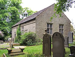
Rivington Church is an active Anglican parish church in Rivington, Lancashire, England. It is in the Deane deanery, the Bolton archdeanery and Diocese of Manchester. The church has been designated a Grade II listed building. The church has no patron saint and is not named after a saint or martyr. It has been variously called St Lawrence, St George, Holy Trinity, and St Catherine but its correct title is Rivington Church.
Nearby Places View Menu

136 m
Rivington
Rivington is a village and civil parish of the Borough of Chorley, Lancashire, England, occupying 2,538 acres (4.0 sq mi; 10.3 km2). It is about 6 miles (9.7 km) southeast of Chorley and about 8+1⁄2 miles (13.7 km) northwest of Bolton. Rivington is a rural area consisting primarily of agricultural grazing land, moorland, with hill summits including Rivington Pike and Winter Hill within the West Pennine Moors. The area has a thriving tourist industry centred around reservoirs created to serve Liverpool in the Victorian era and Lever Park created as a public park by William Lever at the turn of the 20th century, with two converted barns, a replica of Liverpool Castle and open countryside. Rivington and Blackrod High School is located here. Rivington and its village had a population of 109 at the 2011 Census.
214 m
Rivington Unitarian Chapel
Rivington Unitarian Chapel is an active place of Unitarian worship in Rivington, Lancashire, England. It was founded in 1703, although its congregation dates to 1667. It is designated as a Grade II* listed building with some restoration in 1990, and hs ongoing preservation.

524 m
Upper Rivington Reservoir
Upper Rivington Reservoir is situated centrally in the Rivington chain of reservoirs, on the West Pennine Moors in Lancashire, England, between Rivington and Anglezarke. The engineer for the Rivington reservoirs was Thomas Hawksley and construction for Liverpool Corporation Waterworks took place between 1852 and 1857. The two dams of the Upper Rivington reservoir are the 292-yard (267 m) Horrobin Embankment that separates it from the lower reservoir and carries a road into the village from the west, and the 292-yard (267 m) long, 40 foot (12.2 m) high Yarrow Embankment.
There is an island. A bridleway and residence, The Street are on the side of the reservoir. It is a popular walking destination, between Anglezarke Reservoir to the north, Lower Rivington Reservoir to the south, and Yarrow reservoir to the east.
Street Bottoms and Street Wood were lost with the formation of the reservoir.

716 m
Great House Barn
Great House Barn is a 16th-century barn and Listed building in Rivington, Lancashire, England. Built as a tithe barn it is believed to be one of the oldest of its type in the county and is a Grade II listed building.