
 English
 Français
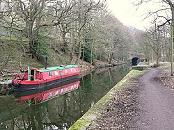
Rochdale Canal
Le Rochdale canal est un canal d'Angleterre, qui tire son nom d'une ville de la banlieue de Manchester. D'une longueur de 51 km, il reliait les nombreuses usines de coton de la ville ainsi que le Canal de Bridgewater et le Sowerby Bridge, dans l'ouest du Yorkshire.
Nearby Places View Menu

11 m
Tuel Lane Lock
Tuel Lane Lock is a canal lock, situated on the Rochdale Canal in Sowerby Bridge, England. It was built in 1996 as part of the canal's restoration, and replaces two previous locks, locks 3 and 4, from the original canal system. With a fall of 19 feet 8.5 inches (6 m), it is the deepest lock in the United Kingdom.
97 m
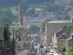
Sowerby Bridge
Sowerby Bridge ( SOR-bi) is a market town in the Upper Calder Valley in Calderdale in West Yorkshire, England. The Calderdale Council ward population at the 2011 census was 11,703.

219 m
Sowerby Bridge railway station
Sowerby Bridge railway station serves the town of Sowerby Bridge in West Yorkshire, England. It lies on the Caldervale Line 4.5 miles (7 km) west of Halifax and 21 miles (34 km) west of Leeds.

250 m
Sowerby Bridge Town Hall
Sowerby Bridge Town Hall is a former municipal building in Town Hall Street in Sowerby Bridge, West Yorkshire, England. The building, which was initially used as the offices of the local board of health and as a public events venue, then as the home of the local Liberal Club and later as a bank branch, is a Grade II listed building.

295 m
River Ryburn
The River Ryburn is a river in West Yorkshire, England. It flows through the villages of Rishworth, Ripponden and Triangle before flowing into the River Calder at Sowerby Bridge.