
 English
 Français

Torphichen
Torphichen ( tor-FIKH-ən) is a historic small village located north of Bathgate in West Lothian, Scotland. The village is approximately 18 miles (29 km) west of Edinburgh, 7 miles (11 km) south-east of Falkirk and 4 miles (6.4 km) south-west of Linlithgow. The village had a population of 570 in the (2011 Census) and a population of 710 in 2016. Torphichen's placename may be Gaelic in origin, e.g., "Tóir Féichín" (the boundary/sanctuary of St Féichín), Tor Fithichean (Hill of the Ravens), or partly from Brythonic "tre fychan" (little town) or small hill.
Nearby Places View Menu

122 m
Torphichen Preceptory
Torphichen Preceptory is a church in the village of Torphichen, West Lothian, Scotland. It comprises the remains of the preceptory (headquarters) of the Knights Hospitaller of the Order of St John of Jerusalem in Scotland. The placename may be Gaelic in origin, e.g., "Tóir Féichín" (the boundary/sanctuary of St Féichín) or Brythonic, e.g., modern Welsh "tref fechan" (little town). The name "Tóir Féichín" with its Gaelic reference to the Boundary/Sanctuary stones set one mile around the village is most likely the true meaning of the village and Preceptory name rather than the modern Welsh which has no historical precedent that overrides the true meaning of those Neolithic sanctuary stones.

1.6 km
A801 road
The A801 is a road in Scotland which runs from east of Polmont to the A705 near Whitburn that heads towards Livingston in the other direction.
The A801 provides a link from Junction 4 of the M8 to Junction 4 of the M9, creating easy access from traffic from Falkirk, Grangemouth or Stirling travelling to and from places in West Lothian like Livingston, Armadale or Bathgate.
2.1 km
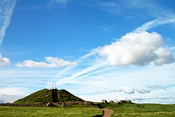
Cairnpapple Hill
Cairnpapple Hill is a hill with a dominating position in central lowland Scotland with views from coast to coast. It was used and re-used as a major ritual site for around 4,000 years, and in its day would have been comparable to better known sites like the Standing Stones of Stenness. The summit lies 312 meters above sea level, and is about 2 miles (3 km) north of Bathgate. In the 19th century the site was completely concealed by trees, then in 1947–1948 excavations by Stuart Piggott found a series of ritual monuments from successive prehistoric periods. In 1998, Gordon Barclay re-interpreted the site for Historic Scotland. It is designated a scheduled ancient monument.

2.4 km
Ballencrief Toll
Ballencrief Toll is a settlement in West Lothian, Scotland. It lies just beyond the northern edge of the town of Bathgate, on the B792 road towards Torphichen.
The area is marked on some maps as Ballencrieff (not to be confused with the Ballencrieff village in East Lothian). The name means "the farm by the tree", from Baile na Craoibhe. From around 1768 until 1880, the abundant limestone was processed locally in kilns to make quicklime.
Immediately south-west of Ballancrieff Toll is the park which surrounded Balbardie House, a grand mansion built in the late 18th century for the influential Marjoribanks family, and demolished between 1954 and 1975. This is now Balbardie Park of Peace, which has a nine-hole golf course and sports facilities including a swimming pool, all run by the non-profit company West Lothian Leisure under their Xcite brand.
A property with two small reservoirs, about half a mile to the north-east, has holiday accommodation and venues for events and weddings.