
 English
 Français

Crowdon
Crowdon is a village in the county of North Yorkshire, England. From 1974 to 2023 it was part of the Borough of Scarborough, it is now administered by the unitary North Yorkshire Council.
Nearby Places View Menu

558 m
Staintondale railway station
Staintondale railway station was 8 miles (13 km) north of Scarborough and served the hamlet of Staintondale in North Yorkshire, England. It opened on 16 July 1885 when the Scarborough & Whitby Railway opened the full line. In 1937 the station was renamed as Stainton Dale (written as two separate words).
The station had two platforms either side of a passing loop and a small goods yard to the west. It was listed in 1904 as being able to handle general goods, livestock, horse boxes and prize cattle vans. There was no permanent crane, although one is shown on the 1893 Ordnance survey map. A camping coach was positioned here by the North Eastern Region from 1954 to 1958 and two coaches were here from 1959 to 1964.
On 4 May 1964 the goods service was withdrawn from the station, which closed completely on 8 March 1965. During the station's final year of operation its average weekly taking was £15 but the wages bill for the station came to £180.
The platforms and the main station buildings (used for residential purposes) are still in place. The railway alignment through the station is used by the Cinder Track, a multi-use path between Scarborough and Whitby.

1.1 km
Staintondale
Staintondale (or Stainton Dale) is a small village and civil parish in the county of North Yorkshire, England. The village is situated 7 miles (11 km) north west of Scarborough town centre. The parish also includes the village of Ravenscar, 2 miles (3 km) north of the village of Staintondale, and the whole parish lies within the North York Moors National Park.
According to the 2011 UK census, Stainton Dale parish had a population of 341, an increase on the 2001 UK census figure of 319 - note these figures includes Ravenscar as well as Staintondale.
The parish council is Staintondale Parish Council.
From 1974 to 2023 it was part of the Borough of Scarborough. It is now administered by the unitary North Yorkshire Council.
The name Staintondale derives from the Old English stāntūndæl meaning 'stone settlement in the dale'.

1.3 km
Hayburn Wyke railway station
Hayburn Wyke railway station was a railway station on the Scarborough & Whitby Railway, 7 miles from Scarborough. It opened on 16 July 1885, and served the popular local beauty spot of Hayburn Wyke, and the Hayburn Wyke Hotel. The platform was originally on the up side of the line, but was moved to the down side on request of the NER.
The station was rebuilt in 1893, and closed temporarily on 1 March 1917. Reopening took place on 2 May 1921 before final, permanent closure on 8 March 1965. From 1955 the station was reduced to an unstaffed halt. The former stationmaster's house dating back to 1892, which stands parallel to the former line, survives as a private residence.
The Cinder Track, a multi-user path used by walkers, cyclists and horse-riders, passes through the station on the line of the old railway, whilst the Cleveland Way lobg-distance footpath passes just to the east.
2.0 km
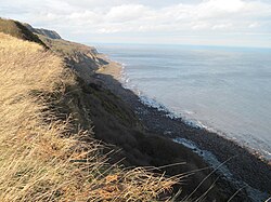
Beast Cliff
Beast Cliff is a steep sea cliff situated about halfway between Whitby and Scarborough on the coast of North Yorkshire in northeastern England. Beast Cliff is at the southern end of a coastal region designated as a Special Area of Conservation and Site of Special Scientific Interest. Bordering the eastern edge of the North York Moors national park, the Cleveland Way runs at the head of the cliffs.
In terms of its position on the Ordnance Survey National Grid system of geographical mapping, Beast Cliff is mostly in the one-kilometre grid square TA0099 but at its northern end it extends into OV. That point is the only area of land in the entire 100-kilometre national grid square of OV, adjoining NZ, SE and TA.