


The William Whalley Homestead is an historic farmstead in Little Compton, Rhode Island. The main house is a 1+1⁄2-story wood-frame structure, probably built sometime between 1815 and 1830. The property includes a late 19th century gabled barn and a stone and wood outbuilding, and is bounded by a low stone wall.
Location
1 explorer visited this place

2.9 km
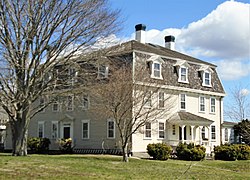
The Friends Meeting House and Cemetery is a historic Quaker meeting house and cemetery at 228A W. Main Road in Little Compton, Rhode Island. The meeting house is a two-story wood-frame structure built in 1815 by the Religious Society of Friends, commonly known as Quakers, on the site of their first meeting house built in 1700 on land granted to John Irish. The new meeting house used some materials from the original one. It was then modified in 1870.
The meeting house was used by Quakers until 1903, and was maintained by members of the Apponegansett Meeting House in Dartmouth, Massachusetts until 1946, when it was donated to the Little Compton Historical Society. It was the Society's first acquisition, and was subjected to a careful restoration beginning in 1963 to restore it to the condition it was in during 1815.
The cemetery, designated Rhode Island Historic Cemetery No. 7, is approximately a 71 foot by 41 foot rectangle located to the east of the meeting house. The earliest dated burials are from 1714 and 1729, and the latest is from 1903. There are 18 inscribed headstones in total, plus multiple uninscribed fieldstone and slate headstones.
The meeting house and cemetery were listed on the National Register of Historic Places in 2007.

3.0 km
The First Baptist Church of Tiverton, commonly called the Old Stone Church, is a historic church property at 7 Old Stone Church Road in Tiverton, Rhode Island. The property consists of a cluster of buildings, including a church, parsonage, and parish house, along with a cemetery, on a largely wooded parcel of 38 acres. The timber-framed field stone church building was built in 1841, the parsonage in 1885, and the parish house c.1879. The oldest documented cemetery burials are from the mid-19th century. Portions of the property are lined by period stone walls, including some that delineate former fields that would have been farmed by the minister. The church was built by a congregation whose roots date to 1680, making it one of the oldest Baptist congregations in the United States.
The church was added to the National Register of Historic Places in 2013.
3.2 km
The Cook–Bateman Farm is a colonial-era farmstead located at the intersection of Fogland, Puncatest Neck and Pond Bridge Roads in Tiverton, Rhode Island. The property was initially purchased in 1700 and reached its largest size, 200 acres, in the last 25 years of the 18th century. It currently encompasses 63 acres of rolling farmland.
The focal point of the farmstead is the 2+1⁄2-story house, the oldest portion of which dates to c.1730–48, while the north kitchen was constructed or rebuilt c.1812-20. Both are now covered by the Second Empire high mansard rook, which was added c.1870. Also on the property is a gambrel-roofed frame barn dating from the late 19th or early 20th century; a two-story hip-roofed frame structure which might be the oldest building in the farmstead, possibly a heabily-altered original farm building from c.1700; a "farmers house"; and a number of other smaller outbuildings.
The property, which has evidence of earlier Native American occupation, including arrowheads and stone tools found in the fields, was purchased by John Cook in 1700, and remained in the hands of just two families for more than 200 years, until 1977.
The farm was listed on the National Register of Historic Places in 1979.

3.4 km
Adamsville is a historic village in Little Compton, Rhode Island, United States. It was first settled in 1675 around the time of King Philip's War and was named after the second president of the United States, John Adams.

3.5 km
Tiverton Four Corners Historic District encompasses the main village center of Tiverton, Rhode Island, United States. The district extends along Main Road north and south from its junction with East Road and Puncatest Neck Road, or West Road. The 50-acre area consists of sixteen historic buildings, predominantly 18th and early 19th-century houses, as well as the 1868 Union Public Library, mill-related resources at the Mill Pond which was situated just southeast of the main intersection, and the A. P. White Store.
Originally inhabited by the Pocasset tribe, John Clarke and William Coddington – who in 1637 had purchased Aquidneck Island across the Sakonnet River from present-day Tiverton from the Narragansett tribe – also obtained from the Wampanoags use of land on the eastern side of the water. Land grants were made by Plymouth Colony as early as 1659, but formal development of the area did not begin until around 1679. After Plymouth Colony was absorbed by Massachusetts, the freemen of the area agitated for separation from it and to be joined to the Colony of Rhode Island. The dispute was not settled until 1746.
The district was added to the National Register of Historic Places in 1974.
The main house is a fairly typical Cape style house, five bays wide, with a central chimney. The property as a whole is a well-preserved example of a typical 19th-century farmstead in the area. The homestead was listed on the National Historic Register in 1988.