
 English
 Français
Cromlech de Castlerigg
Le cromlech de Castlerigg est un cromlech situé sur le territoire de la commune britannique de Keswick, dans le comté anglais de Cumbria. Il est le cromlech le plus touristique de Cumbria et fait partie des propriétés de l’English Heritage.
Nearby Places View Menu

64 m
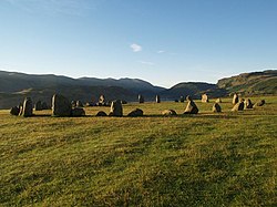
Castlerigg stone circle
Castlerigg Stone Circle (alternatively Keswick Carles, or Carles) is situated on a prominent hill to the east of Keswick, in the Lake District National Park, North West England. It is one of around 1,300 stone circles in the British Isles and Brittany, constructed as a part of a megalithic tradition that lasted from approximately 3200 BC to 2500 BC, during the Late Neolithic and Early Bronze Ages.
Various archaeologists have mentioned the beauty and romance of Castlerigg and its surrounding landscape. In his study of the stone circles of Cumbria, archaeologist John Waterhouse commented that the site was "one of the most visually impressive prehistoric monuments in Britain."
Every year, thousands of tourists travel to the site, making it the most visited stone circle in Cumbria. This plateau forms the raised centre of a natural amphitheatre created by the surrounding fells and from within the circle it is possible to see some of the highest peaks in Cumbria: Helvellyn, Skiddaw, Grasmoor and Blencathra.

780 m
Briery Siding Halt railway station
Briery Siding Halt railway station served the workers of Briery Bobbin Mill in Briery, in the historical county of Cumberland, England, from 1922 to 1958 on the Cockermouth, Keswick and Penrith Railway.

856 m

1.3 km
Glenderaterra Beck
Glenderaterra Beck is a watercourse in the county of Cumbria, England.
The length of the Glenderaterra, and its major tributary Whit Beck is 4.8 miles (7.8 km), which have a total catchment area of 11.8 square kilometres (4.6 sq mi).
The beck runs from its source on Burnt Horse through the valley between Lonscale Fell and Blencathra to its confluence with the River Greta at Brundholme near Threlkeld.
Although the top of the stream from Burnt Horse is widely cited as the source of the Glenderaterra, the Royal Geographical Society and other authorities state that the source of a river is the furthest point from its mouth or confluence with the river it meets downstream, regardless of names attached to the contributing flows. So, the source must be Roughten Gill which starts on Blencathra, under Halls Fell top and turns the corner at a delightful and well-hidden sheepfold. It is longer than the stream in Sinen Gill which in turn is longer than the Burnt Horse contributor.
On its southerly course, Glenderaterra Beck is joined by Sinen Gill and Roughten Gill, draining Blease Fell on Blencathra, and, lower down, Whit Beck, emanating from Jenkin Hill on Skiddaw.
This river is used by Geography students for A Level and GCSE field studies.
1.4 km
Chestnut Hill, Cumbria
Chestnut Hill is a suburb of Keswick, England, located along the A591 road. It contains the Nether Place Nursing Home and Claremont House, a 19th-century lodge which is an AA 4 diamond hotel.