
 English
 Français

Ardrishaig
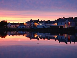
Ardrishaig (Scottish Gaelic: Àird Driseig) is a coastal village on Loch Gilp, at the southern (eastern) entrance to the Crinan Canal in Argyll and Bute in the west of Scotland. It lies immediately to the south of Lochgilphead, with the nearest larger town being Oban.
Nearby Places View Menu

2.2 km
Kilduskland Reservoir
Kilduskland Reservoir is of the impounding variety and is located 2 kilometres west of Ardrishaig, supplying the village with its water supply. The concrete dam is 9 metres high and it was completed in 1906.

2.4 km
Loch Gilp
Loch Gilp (Scottish Gaelic: Loch Gilp) is a small inlet on Loch Fyne, Argyll and Bute, west of Scotland. The loch gives its name to the nearby town of Lochgilphead. The Crinan Canal extends from the loch across to Crinan itself.

2.4 km
Kilmory Castle
Kilmory Castle, also known as Kilmory House, is a large 19th century house located just to the south of Lochgilphead, in old county Argyll, on the west coast of Scotland. It is currently occupied by the headquarters of the Argyll and Bute Council. The gardens are open to the public and form part of a country park on the former estate. The house is protected as a category B listed building.
3.2 km
Lochgilphead
Lochgilphead (; Scottish Gaelic: Ceann Loch Gilb [kʲʰan̪ˠ l̪ˠɔx ˈkʲilip]) is a town and former burgh in Argyll and Bute, Scotland, with a population of around 2,300 people. It is the administrative centre of Argyll and Bute Council. The village lies at the end of Loch Gilp (a branch of Loch Fyne) and lies on the banks of the Crinan Canal. Lochgilphead sits on the A83, with Ardrishaig 2 miles (3 km) to the south and Inveraray 24 miles (39 km) to the north-east; Oban lies 37 miles (60 km) north on the A816.
The council is based at Kilmory Castle, around which is located a woodland park and an Iron Age fort. Forestry and Land Scotland also have an office there.