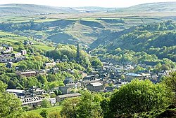
Mankinholes is a hamlet in the Metropolitan Borough of Calderdale, in West Yorkshire, England. It is situated in the Pennines and the nearest town is Todmorden. The hamlet is part of Calder Ward in Calderdale Parish Council. It has a YHA hostel, managed by the larger hostel at nearby Haworth. Mankinholes is the starting point for the popular trek up Stoodley Pike (pike being a North-country term for a mountain or large hill). The hill is surmounted by a 19th-century obelisk, 120 feet (37 m) high, also known as "Stoodley Pike", commemorating the end of the Crimean War. The name "Mankin" is believed to have Celtic origins, with the OED recording its first meaning as "fierce wild man". The surname Mankin is found in parish records of the township of Langfield and the parish of Halifax. One theory is that the name derives from an area of caverns, inhabited by mankins. A second theory is that the name means "Mancan's Hollow", Mancan being an Irish surname. This would indicate an Irish-Viking settlement. Mankinholes was an early centre of Wesleyan Methodism. Groups met in farmhouses as early as the late 18th century and the first chapel was built in 1814. This was enlarged in 1870 and rebuilt in 1911. An adjacent Sunday School was built in 1833. Mankinholes Methodist Church closed on 1 July 1979, when the congregation joined with that of Lumbutts Methodist Church, situated midway between the villages of Mankinholes and Lumbutts. The Mankinholes Sunday School building still stands and is now a private house, surrounded by a large graveyard.

Nearby Places View Menu
Location Image
347 m

Lumbutts

Lumbutts is a former mill village just to the south of Todmorden, in West Yorkshire, England. Lumbutts and the adjacent village of Mankinholes, were traditionally hand-loom weaving villages located on an old packhorse route that traversed the southern side of the Calder Valley. The village is east of Rochdale and west of Halifax.
Location Image
1.8 km

Stoodley Pike

Stoodley Pike is a 1,300-foot (400 m) hill in the south Pennines in West Yorkshire in northern England. It is noted for the 121-foot (37 m) Stoodley Pike Monument at its summit, which dominates the skyline above the market town of Todmorden and the moors of the upper Calder Valley. The monument is near the villages of Lumbutts and Mankinholes, West Yorkshire, and was designed in 1854 by local architect John Green, and completed in 1856 at the end of the Crimean War. The monument replaced an earlier structure, started in 1814 (1814) and commemorating the defeat of Napoleon and the surrender of Paris. It was completed in 1815, after the Battle of Waterloo (Napoleonic Wars), but collapsed in 1854 after an earlier lightning strike, and decades of weathering. Its replacement was therefore built slightly further from the edge of the hill. During repair work in 1889 a lightning conductor was added, and although the tower has since been struck by lightning on numerous occasions, no notable structural damage is evident. There is evidence to suggest that some sort of structure existed on the site even before the earlier structure was built. The monument is approximately 2 miles (3.2 km) south west of Hebden Bridge and approximately 2.5 miles (4 km) east of Todmorden town centre. The monument was Grade II listed in 1984. The inscription above the entrance is worn and covered with lichen but it is legible and reads: STOODLEY PIKE A PEACE MONUMENT ERECTED BY PUBLIC SUBSCRIPTION COMMENCED IN 1814 TO COMMEMORATE THE SURRENDER OF PARIS TO THE ALLIES AND FINISHED AFTER THE BATTLE OF WATERLOO WHEN PEACE WAS ESTABLIS- HED IN 1815. BY A STRANGE COINCIDENCE THE PIKE FELL ON THE DAY THE RUSSIAN AMBASSADOR LEFT LONDON BEFORE THE DECLARATION OF WAR WITH RUSSIA IN 1854 WAS REBUILT WHEN PEACE WAS RESTORED IN 1856 REPAIRED AND LIGHTNING CONDUCTOR FIXED 1889
Location Image
2.0 km

Todmorden

Todmorden ( TOD-mər-dən; locally ) is a market town and civil parish in the Upper Calder Valley in Calderdale, West Yorkshire, England. It is 17 miles (27 kilometres) north-east of Manchester, 8 miles (13 km) south-east of Burnley and 9 miles (14 km) west of Halifax. In 2011, it had a population of 15,481. Todmorden is at the confluence of three steep-sided Pennine valleys and is surrounded by moorlands with outcrops of sandblasted gritstone. The historic boundary between Yorkshire and Lancashire is the River Calder and its tributary, Walsden Water, which run through the town. The administrative border was altered by the Local Government Act 1888 placing the whole of the town within the West Riding. The town is served by Todmorden and Walsden railway stations.
Location Image
2.1 km

Todmorden Markets

Todmorden Markets consist of an indoor market held in the Public Market Hall and an outdoor open air market held to the front of the Public Market Hall in central Todmorden adjacent to the Town Hall. The indoor market has over 40 market traders stalls selling fresh produce, meat, dairy produce, bread, ironmongery, books, clothing, carpets and speciality and ethnic foods. Official opening times of the Public Market Hall are Monday to Saturday (half day closing Tuesday) 9.00am to 5.30pm The outdoor market is open 9.00am to 4.00pm Wednesday, Thursday, Friday, Saturday and Sunday. Thursday is exclusively a second hand market whereas Sunday is a mix of general retail and second hand goods. The two markets are operated by Calderdale Council.