
 English
 Français
Port of Tyne
The Port of Tyne comprises the commercial docks on and around the River Tyne in Tyne and Wear in the northeast of England.
Nearby Places View Menu
262 m
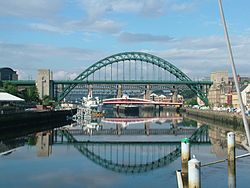
Tyneside
Tyneside is a built-up area across the banks of the River Tyne in Northern England. The population of Tyneside as published in the 2011 census was 774,891. Tyneside is made up of the metropolitan boroughs of Newcastle upon Tyne, Gateshead, North Tyneside and South Tyneside. The area is surrounded by the North East Green Belt. Residents of the area are commonly referred to as Geordies.
401 m
Tyne Renewable Energy Plant
Tyne Renewable Energy Plant (or Tyne REP) was a proposed biomass power station, to be built on the north bank of the River Tyne at North Shields. The plant was developed by MGT Power, along with their similar project, the Teesport Renewable Energy Plant on Teesside. It was expected to have a generating capacity of 295 megawatts, enough to power around 600,000 homes, meaning it would have been one of the biggest of its kind in Europe. It was originally hoped the plant would be opened in 2014, costing £400 million.
The plant was planned to be built on a 14 acres (5.7 ha) industrial site at the Port of Tyne in North Shields adjacent to the proposed North Shields Bio Diesel Plant on the north bank of the River Tyne. The construction of the plant was estimated to create around 600 jobs, as well as 150 full-time jobs once the plant was completed, and 300 to 400 indirect jobs in the supply chain. It was expected to have added an annual spend of £30 million in the local economy.
As of 2016, MGT were no longer actively pursuing plans for the plant.
742 m
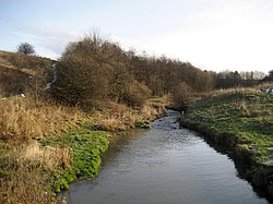
River Don, Tyne and Wear
The River Don is a 15.4 kilometres (9.6 mi) long tributary of the River Tyne in Tyne and Wear, North East England.
It rises near Springwell and flows east for about 6 km, then turns north. At the Brockley Whins Metro station, it flows through a culvert before flowing out at Monkton. It flows under the Jarrow Bridge and meets the River Tyne at Jarrow. For much of its length in the upper section, it is the boundary between Gateshead and Sunderland.
Tributaries of the Don includes the Bede's Burn, Monkton Burn, Calfclose Burn, Station Burn, Usworth Burn, and Whittle Burn.
The River Don's mouth was altered in the mid-20th century, and a remnant still remains to the old course near the mouth.
786 m
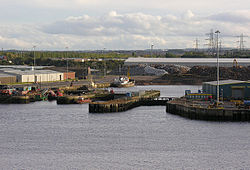
Tyne Dock
Tyne Dock is a neighbourhood within the town of South Shields, Tyne and Wear, on the south bank of the River Tyne. It takes its name from the large dock on the river which was opened in 1859 by the North Eastern Railway (and acquired by the Tyne Improvement Commission in 1938) to handle Tyneside's coal exports. At its height the trade amounted to seven million tons of coal transported via the four staiths which had been built to facilitate the process. This trade declined in the second half of the twentieth century and the bridges that carried the coal trains into the dock, the famous Tyne Dock Arches, were demolished from 1977 on. The dock itself has been progressively infilled since closure, allowing for the building of modern storage warehouses. This process concluded with the final 13 acres that were filled in as part of the project to build the second Tyne Tunnel. The Tyne Dock basin was filled with 400,000 cubic metres of sediment dredged from the Tyne.