
 English
 Français
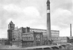
Wilton Mill, Radcliffe
Wilton Mill, Radcliffe was a cotton spinning mill in Radcliffe, Bury, Greater Manchester. It was built in 1907 and was taken over by the Lancashire Cotton Corporation in 1930 and passed to Courtaulds in 1964. Production finished in 1965, after which it was used by the East Lancashire Paper Company but has now been demolished leaving an empty site next to the railways and the River Irwell.
Lieux à Proximité Voir Menu

211 m
Radcliffe tram stop
Radcliffe is a tram stop in the town of Radcliffe, Greater Manchester, England. It is on the Bury Line of Greater Manchester's light rail Metrolink system.

561 m
Radcliffe, Greater Manchester
Radcliffe is a market town in the Metropolitan Borough of Bury, Greater Manchester, England. It lies in the Irwell Valley 7 miles (11 km) northwest of Manchester and 3 miles (5 km) southwest of Bury and is contiguous with Whitefield to the south. The disused Manchester Bolton & Bury Canal bisects the town.
Evidence of Mesolithic, Roman and Norman activity has been found in Radcliffe and its surroundings. A Roman road passes through the area, along the border between Radcliffe and Bury. Radcliffe appears in an entry of the Domesday Book as "Radeclive" and in the High Middle Ages formed a small parish and township centred on the Church of St Mary and the manorial Radcliffe Tower, both of which are Grade I listed buildings.
Plentiful coal in the area facilitated the Industrial Revolution, providing fuel for the cotton spinning and papermaking industries. By the mid-19th century, Radcliffe was an important mill town with cotton mills, bleachworks and a road, canal and railway network.
At the 2011 Census, Radcliffe had a population of 29,950. Radcliffe is predominantly a residential area whose few remaining cotton mill buildings are now occupied by small businesses.
At the 2021 Census, the population of Radcliffe had seen an increase, rising to 31,307.
622 m
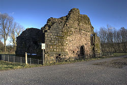
Radcliffe Tower
Radcliffe Tower is the only surviving part of a manor house in Radcliffe, a market town in the Metropolitan Borough of Bury, Greater Manchester (historically in Lancashire), England. It is a scheduled monument and a Grade I listed building. The house was rebuilt in 1403 by James de Radcliffe, lord of the manor of Radcliffe, and comprised a stone-built hall and one or two towers, probably constructed with ashlar blocks. De Radcliffe was granted a royal licence to fortify the site, including the addition of crenellations and battlements.
The manor house was demolished in the 19th century, leaving only the tower, which measures 31.5 feet (9.6 m) by 57 feet (17 m) and survives to a height of about 20 ft (6.1 m). The remains are owned by Bury Council. It was used as a pigsty before being restored. Radcliffe Tower is about 3.3 kilometres (2.1 mi) south of Bury Castle, a late 15th-century moated manor house.
In 2009 plans to restore the shell of the tower as part of a wider restoration project covering Radcliffe E'es, Close Park, and the parish church of St Mary were launched with the support of Bury Council.
Since 2012, archaeological excavations funded by the Heritage Lottery Fund have uncovered medieval glazed floor tiles, roof tiles, and pottery from the 15th century.

636 m
Radcliffe bus station
Radcliffe bus station is a bus station in Radcliffe, Greater Manchester and, in its previous form, opened in April 1984. It was situated on Dale Street in Radcliffe.
The newly constructed Radcliffe bus station is situated at the junction of the A665 (Pilkington Road) and Dale street, Radcliffe.