
 English
 Français
Newbridge Drive
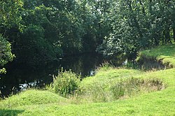
Newbridge Drive is a relatively new suburb in Dumfries. It is situated on the Maxwelltown side of the River Nith and is approx 1.8 miles north-west from Dumfries town centre.
Nearby Places View Menu
783 m
Maxwelltown High School
Maxwelltown High School was a state funded, six-year comprehensive secondary school in the Lochside area of Dumfries, Scotland. Founded in 1971, Maxwelltown High School was the most recently founded secondary school in Dumfries and Galloway, before merging with other schools into North West Community Campus. It had 311 pupils as of August 2012. The roll of Maxwelltown High School had been steadily declining since 2002.
Although attainment throughout the school was generally lower than the national averages for equivalent qualifications, this improved in later years and the school was known as being a leader in curriculum development.

883 m
Lincluden Collegiate Church
Lincluden Collegiate Church, known earlier as Lincluden Priory or Lincluden Abbey (the name by which it is still known locally), is a ruined religious house, situated in the historic county of Dumfries to the north of the Royal Burgh of Dumfries, Scotland. Situated in a bend of Cluden Water, at its confluence with the River Nith, the ruins are on the site of the Bailey of the very early Lincluden Castle, as are those of the later Lincluden Tower. This religious house was founded circa 1160 and was used for various purposes, until its abandonment around 1700. The remaining ruins are protected as a scheduled monument.
1.1 km
Cairn Water
Cairn Water is a small river in Dumfries and Galloway, Scotland. The river, formed by the confluence of the Castlefern, Craigdarroch and Dalquhat, flows for 11.5 miles (18.5 km) southeast to the Cluden.
The Castlefairn is joined by the Craigdarroch and then by the Dalwhat, both from its left, just below the village of Moniaive in the parish of Glencairn.
The confluence of these streams forms the Cairn Water. The parish is named for the river valley. The river flows east past Kirkland, then southeast to Newtonairds, where it is joined by the Old Water to form Cluden Water. Cluden Water flows east and southeast to join the River Nith just north of Dumfries. The entire stretch of river from Moniaive to the Nith is known locally as the River Cairn.
The river once defined part of the boundary between Dumfriesshire to the east and Kirkcudbrightshire to the west.

1.6 km
Twelve Apostles Stone Circle
The Twelve Apostles (grid reference NX9470079400) is a large stone circle located between the villages of Holywood and Newbridge, near Dumfries, Scotland. It is the seventh largest stone circle in Britain and the largest on the mainland of Scotland. It is similar in design to the stone circles of Cumbria, and is considered to be an outlier of this group. Its south-westerly arrangement aligns it with the midwinter sunset.
It is a scheduled monument.