
 English
 Français

Devil's Beef Tub
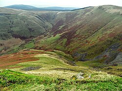
The Devil's Beef Tub (Marquis of Annandale's Beef-Tub, Beef-Stand, MacLaren's Leap) is a deep, dramatic hollow in the hills north of the Scottish town of Moffat. The 150-metre-deep (490-foot) hollow is formed by four hills, Great Hill, Peat Knowe, Annanhead Hill and Ericstane Hill. It is one of the two main sources of the River Annan.
Nearby Places View Menu
650 m
Annanhead Hill
Annanhead Hill is a 478-metre (1,568 ft) summit in the Moffat Hills of Scotland. It lies on the boundary between the Scottish Borders and Dumfries and Galloway, 9 kilometres (5.6 mi) north of Moffat, in the Southern Uplands.
Annanhead is one of four hills encircling the Devil's Beef Tub, the headwaters of River Annan.
The hill is crossed by the Annandale Way hiking trail designated in 2009.

2.3 km
Crown of Scotland (hill)
The Crown of Scotland is a hill in the Scottish Borders, Scotland.
At a relatively small elevation from the surrounding peaks, it is situated to the north of the Devil's Beef Tub and the town of Moffat.
The hill's unusual name derives from the alliance made between Robert the Bruce and James Douglas, Lord of Douglas upon its summit in 1306, following the former's murder of the Red Comyn at Greyfriars kirk in Dumfries, and when Bruce was on his way to Scone to be crowned by Bishop William de Lamberton.
4.0 km
Greenhillstairs
Greenhillstairs is the steep B719 road north of Moffat in Dumfries and Galloway, Scotland. The road, about 3 miles long, leaves the A701 Moffat to Edinburgh main road passes over the A74(M) and then joins the B7076 service road running parallel to the motorway. The B719 descends steeply into the Evan Water valley with views across the valley.

7.3 km
Beattock Summit
Beattock Summit is the highest point of the West Coast Main Line (WCML) railway and of the A74(M) motorway as they cross between Dumfries and Galloway and South Lanarkshire in south west Scotland.
The height of the summit reached by the A74(M) motorway is 1,033 feet (315 m) above sea level. The adjacent railway reaches a slightly lower elevation of 1,016 feet (310 m). The summit is the watershed between the River Clyde to the north and Evan Water, a tributary of the River Annan to the south.