


Quamash Prairie Natural Area is a 160-acre protected wet prairie in Washington County, Oregon and bounded by the Tualatin River. It is co-administered by Oregon Metro and the Confederated Tribes of Grand Ronde. It is specifically managed as a camas prairie.
Book your tour near
Quamash Prairie Natural Area
Book Now
4.3
in partnership with
GetYourGuide.com
Location
1 explorer visited this place
1.0 km
Scholls, Oregon is an unincorporated community in Washington County, Oregon, United States. It is located along the southern shore of the Tualatin River, near the intersection of Oregon Routes 210 and 219. Scholls is located approximately seven miles north of Newberg, seven miles west of Tigard and eight miles south of Hillsboro. The area around Scholls is primarily agricultural.

2.1 km
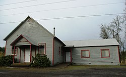
Midway is an unincorporated rural community in Washington County, Oregon, United States. It is located on Oregon Route 219 about 2.5 miles west of Scholls. The area is the halfway point between Hillsboro to the north and Sherwood to the southeast, thus it became known as Midway. Midway has a large plant nursery business, a bar and grill and a rural fire station for Washington County Fire District 2.
Midway's 1912 former one-room schoolhouse, closed in 1946, has been preserved as a private residence. Before being converted into a home, it served as a lodge for the Odd Fellows and Rebekahs. When the school closed, Midway School District merged with the Jacktown, Groner and Kinton school districts to form the Groner School District, which along with other small districts such as Farmington View later merged into the Hillsboro School District.

2.9 km
Laurelwood District is an American Viticultural Area located west of the city of Portland and lies entirely within the northern end of Willamette Valley AVA and within the smaller nested Chehalem Mountains AVA. The Chehalem Mountains are a main defining feature along with the area's unique soil profile, and the AVA includes portions of the towns of Cornelius, Scholls and Sherwood in Washington County. It was established as the nation's 248th, the state's 21st and the valley's tenth wine appellation on June 3, 2020 by the Alcohol and Tobacco Tax and Trade Bureau, Treasury after reviewing the petition submitted by Luisa Ponzi, then-winemaker of Ponzi Vineyards, Maria Ponzi, then-president of Ponzi Vineyards, and Kevin Johnson, winemaker of Dion Vineyards, on behalf of themselves and other local grape growers and vintners, proposing the viticultural area to be known as "Laurelwood."
At the request of TTB, the petitioners agreed to add the word "District" to the proposed name, in order to avoid a potential impact on current label holders who are using "Laurelwood" as a brand name or fanciful name on their wine labels. Its acreage is approximately 33,600 acres with, at the outset, is resident to 25 wineries and approximately 70 commercially-producing vineyards cultivating approximately 975 acres. The Laurelwood District's main distinguishing feature is the predominance of Laurelwood soil, a windblown loess over fractured Jory basalt. The district contains the highest concentration of the namesake soil in Oregon. Other defining features of the AVA are its location among the Chehalem Mountains - granting it the highest planted sites in the Willamette Valley, and its proximity to warm wind influence from the Columbia River Gorge.

4.0 km
The Chehalem Mountains AVA is an American Viticultural Area located in the Yamhill and Washington counties of northwestern Oregon. It contains two sub-regions, Laurelwood District AVA and Ribbon Ridge AVA.
4.7 km
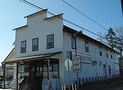
Laurel is an unincorporated community in Washington County, Oregon, United States. Settled in 1872, the community is located between Hillsboro and Newberg, in the southern portion of the Tualatin Valley in the foothills of the Chehalem Mountains. The community retains its agricultural heritage. Laurel is served by the Hillsboro School District and includes the century-old Laurel Valley Store building, which is in the process of being turned into a restaurant. As an unincorporated community, Laurel has no defined boundaries or population statistics of its own.