


Bayou Dupre is a bayou in southeastern Louisiana.
Location
1 explorer visited this place

6.9 km
Violet is a census-designated place in St. Bernard Parish, Louisiana, United States. The population was 5,758 at the 2020 census. Violet is located on the east bank of the Mississippi River, approximately 7.5 miles southeast of New Orleans and is part of the Greater New Orleans area.

7.0 km
Battery Bienvenue is a ruined coastal gun battery located in St. Bernard Parish, Louisiana. It was built as part of the harbor defense of New Orleans, and located at a strategic fork where Bayou Bienvenue and Bayou Villeré join. Bayou Bienvenue, from Lake Borgne, was the route used by the British late in 1814 to approach the city.
The battery was first constructed in 1815 and improved over the years. The initial armament was planned for one 24-pounder and two 18-pounder cannons. In 1826, the plan expanded to twenty-four 32-pounders and two 13-inch mortars with a garrison of one artillery company.
Eventually four buildings occupied the parade ground: barracks, officers quarters, a guardhouse, and an artillery magazine. The battery was about 600 feet wide, with the guns pointed toward the mouth of Bayou Bienvenue and was surrounded by a moat that connected to the bayou. The battery was abandoned a few years after the American Civil War, in 1872.

7.6 km
Bayou Bienvenue is a 12.1-mile-long bayou and "ghost swamp" in southeastern Louisiana. It runs along the political border between Orleans Parish and St. Bernard Parish to the east of New Orleans. The Bayou Bienvenue Wetlands Triangle viewing platform in the Lower Ninth Ward provides expansive views of the bayou and also serves as an educational resource about restoration efforts in the area.
A part of the central wetlands system that ran from the Lower 9th Ward all the way to Lake Borgne, today only roughly 400 acres remain of the once thriving cypress swamp. Like other freshwater bayous throughout the Mississippi River Delta, Bayou Bienvenue consisted of old growth cypress and many native species of plants and animals; "What is now open water used to be an old–growth swamp that was filled with cypress trees, water lilies, and freshwater wildlife such as fish, alligators, otters, birds, and crawfish. The cypress trees were once so thick you could pull yourself along in a canoe or pirogue just by reaching out to grab cypress knees."
Beyond its ecological significance, Bayou Bienvenue has served cultural functions to the populations of the surrounding areas throughout the area's history of human occupation. Archaeological digs have yielded evidence that indigenous peoples of hunter-gatherer societies inhabited the area as far back as 400 A.D. The arrival of French explorers in the late 1600s began nearly two centuries of disagreements, disputes, and armed confrontations between French, Spanish, British and later American interests as the colonial era of North America progressed. Bayou Bienvenue gained its name during the initial French occupation; 'bayou bienvenue' is French for "welcome bayou".
From the beginning of European exploration of North America, slave labor was used to facilitate the interests of the colonizing powers. Under French rule, the enslaved population included indigenous peoples as well as Africans brought to the Americas in the Atlantic slave trade. By 1828, New Orleans was center of the United States slave trade. With its location five miles from the center of New Orleans, Bayou Bienvenue became home to a community of Maroons, freed slaves. Who were Maroons, and what was their relationship to [the landscape of Bayou Bienvenue]?
Maroons were self-described liberated enslaved people who lived in the wetlands. For Europeans, the wetlands were associated with death and fear, but for Maroons they held the possibility of new life. Liberated enslaved people, especially of African origin, would escape into the wetlands because of the similarity to the landscapes of their origins. Maroons lived alongside Indigenous communities that were there before them, like the Chitimacha and Choctaw Tribes and Acadians, who had arrived when Britain colonized Canada. These societies developed various techniques for living in the wetland environment without damaging it, including raised housing, small watercraft-like pirogues, and a new cuisine of alligator and turtles. Each group brought their knowledge of cooking, animals, plants, medicines, and building.
Eventually, industry and plantations began to exert pressures on these communities and how they used the landscape. To earn money, Maroons made wares with grass-weaving techniques they had learned from the Chitimacha. Enslaved people whom Maroons had relationships with would take the wares and sell them at the slave market in New Orleans. Lumber companies would also bring enslaved people into the wetlands to harvest cypress for building materials. Through the connections between the enslaved and Maroons, lumber companies would pay Maroons, who were deeper in the wetlands, to cut timber. However, this practice was not beneficial to Maroon communities because the logging participated in the destruction of the wetlands that protected them. As the wetlands became navigable with more shipping channels and canals, the Maroons were increasingly hunted down. Maroon communities still existed in wetlands elsewhere, like Brazil and Jamaica, but in Bayou Bienvenue their communities ceased to exist either through capture or destruction of the landscape that had sustained them.Though in 1769, the Spanish government abolished the enslavement of indigenous people, the Maroon communities of the swamps surrounding New Orleans were a major source of anxiety for the powerful leaders of Spanish Louisiana. The Maroons' reputation grew to mythical proportions, though their numbers were significantly lower than what the Spanish government believed. Jean Saint Malo led a group of Maroons in the areas west of Bayou Bienvenue between 1780 and 1784, when Spanish Lieutenant Governor Francisco Bouligny was ordered to eradicate the Maroons, including Saint Malo's group. After Saint Malo's capture and subsequent execution, Maroon communities were largely driven out of the greater New Orleans area, including Bayou Bienvenue, by the late 1700s.
The area remained significant throughout for its connection for ships to travel between the New Orleans area and Lake Borgne, creating a shortcut to the Gulf of Mexico, throughout the transition to American rule after the Louisiana Purchase. This proved of significant benefit to the British during the Battle of New Orleans in 1814. "The British had done the impossible. Two officers, disguised as locals, had found the one bayou leading from Lake Bourgne to the Mississippi River that the Creoles, ignoring Jackson’s repeated orders, had failed to block. Suitably named Bienvenue, it had welcomed the midnight passage of General Keane, 2,080 men, and two guns to firm ground on the Villeré plantation along the Mississippi. At dawn on December 23, they had surrounded and taken prisoner the militia detachment supposedly guarding the bayou."The British were defeated after the Battle of New Orleans, waged just five miles downriver from New Orleans and just beyond Bayou Bienvenue at the Chalmette Battlefield in St. Bernard Parish. A short distance from the Lake end of Bayou Bienvenue, the remains of Battery Bienvenue still guard the eastern approach to the city. This fortification was built shortly after 1815's Battle of New Orleans to prevent any future invasion of the city by way of the Lake and Bayou.
The growth of New Orleans in the early 20th century led to part of Bayou Bienvenue being drained for expansion of the city. In the 1920s, the dredging and installation of locks creating the Industrial Canal, which connected Lake Pontchartrain to the Mississippi River, marked the beginning of the man-made interference that lead to the eventual demise of the Bayou Bienvenue cypress swamp.
The creation of the Mississippi River Gulf Outlet in the 1960s "funneled directly into the bayou from the Gulf, and quickly killed the cypresses, oaks and almost every other tree, as well as much of the shrub and grass. The wildlife vanished with the habitat ... the area has been decimated, eroded and virtually marinated in salt water." Today a "ghost swamp", the only visible remnants of the Bayou before its man-made destruction are the skeleton-like, limbless trunks of the dead cypress trees rising out of the brackish water.
The bayou crosses the Gulf Intracoastal Waterway and Mississippi River Gulf Outlet, before ending in Lake Borgne, a shallow estuarine lake branching from the Mississippi Sound.

7.8 km
Saint Bernard is an unincorporated community in St. Bernard Parish, Louisiana, United States. It was established in the 18th century during Louisiana's Spanish colonial era as the center of Isleño settlers. The community is located on Louisiana State Highway 300, east of the Mississippi River and 8 miles southeast of Chalmette. In addition to the historic village of Saint Bernard, the "Saint Bernard" name is often used informally and for mailing addresses to include other nearby unincorporated communities in the Terre-Aux-Boeufs area.
The Dr. Louis A. Ducros House is on the National Register of Historic Places, as are nearby Kenilworth Plantation House, and the Sebastopol Plantation House in Sebastapol near Poydras, Louisiana.
7.8 km
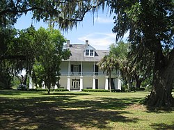
The Kenilworth Plantation House is a historic plantation house located at 2931 Bayou Road in St. Bernard Parish, Louisiana, United States. According to a sign in front of the house, the French Creole style house was built in 1759. It was on this date that the lower half of the home was completed as a livable space.Its nomination to the National Register of Historic Places, however, indicates it was built circa 1820. During the early 19th century, the French Creole style was the predominant architectural form of St. Bernard Parish; however, most of the parish's French Creole buildings from the period are no longer standing, and Kenilworth is one of the best-preserved examples of the style.
The two-story house has a raised basement, and the upper story is considered the primary living space. A gallery supported by turned colonnettes surrounds both stories of the house; all entrances from the gallery feature French doors. The house's hipped roof has an intricate truss support system and exposed, shaped rafter tails typical of Creole designs.
Since 1964, the home has been owned by Dr. Valentino Acosta, an Arabi dentist and his family.
The house was added to the National Register of Historic Places on April 24, 2006.
The house was a filming location for the movie Stay Alive. Much earlier, in 1961 The Dead One, a regionally produced horror film written, produced and directed by Barry Mahon, was filmed at Kenilworth for the exterior and in New Orleans for interior scenes. At the time, the home had recently been purchased by Rupert and Elise Stuart of New Orleans, and its rundown appearance lent itself to the spirit of the film, which is now considered a classic in zombie film history and available on DVD.