
 English
 Français
Lindores Loch
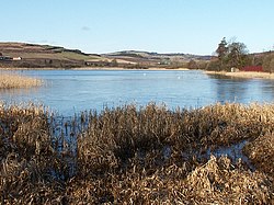
Lindores Loch is a freshwater loch, situated in North Fife in the Parish of Abdie, in the Central Belt of Scotland. The Loch has for many years been used as a fishery and is well known for its abundant fish life. A curling pond is situated on the Northern shoreline and is nominally used by the Abdie Curling Club and Abdie ladies Curling Club. A speculative study suggests that the loch was created by glacial deposits from the surrounding Ochil Hills at the end of the last ice-age. The water level and shoreline have changed over time due to roads, railway, sluice gate and farmland.
Nearby Places View Menu
745 m
Lindores
Lindores is a small village in Fife, Scotland, in the parish of Abdie, about 2 miles south-east of Newburgh. It is situated on the north-east shore of Lindores Loch, a 44 ha freshwater loch. A possible derivation of the name Lindores is 'church by the water'. The ruins of Abdie church, about 0.5 miles south-west of the village are possibly the site of an ancient shrine connected to the Celtic foundation at Abernethy. After the foundation of Lindores Abbey in 1191 the church was given to the abbey.
The Abdie stone, a Pictish stone dating from the 6th or 7th century stood on a nearby ridge until around 1850, but is now in the church yard housed in a modified morthouse.
Traces of an ancient castle, thought to have belonged to Macduff, Thane of Fife, have been found at the eastern end of the village. The battle of Black Irnsyde, at which William Wallace defeated Aymer de Valence, the 2nd Earl of Pembroke, is claimed to have been fought near the village, though this does not fit with known historical facts.

810 m
Lindores railway station
Lindores railway station served the village of Lindores, Fife, Scotland from 1909 to 1951 on the Newburgh and North Fife Railway.
1.1 km
Lindores (E&NR) railway station
Lindores (E&NR) railway station was a temporary terminus that served the village of Lindores, Fife, Scotland in 1847 on the Edinburgh and Northern Railway.

1.2 km
Cairnie Hill
Cairnie Hill lies at the eastern end of the Ochil Hills, above the village of Collessie Scotland. It is the highest point of a small upland area between Collesie Den and Collairnie Farm. The northern and western slopes of Cairnie Hill are quite steep and are used for rough grazing and forestry. To the south the land rises gradually from the flat Howe of Fife and is used predominantly for arable farming.
Cairnie is a common place name in Fife, possibly originating from the Pictish Carden or thicket, with the addition of the Gaelic ending aigh.
It is also Scots for 'hillock'.
An easy route to the summit starts at NO 273153, on the B937 about 2 km south of Lindores. From here a track leads up onto the summit area, from where several paths lead to the summit.