


Mount Tom State Park is a public recreation area lying south of US Route 202 in the towns of Washington, Litchfield, and Morris, Connecticut. The state park occupies 231 acres (93 ha) on the southwest shore of Mount Tom Pond and is home to the Mount Tom Tower, which was listed on the National Register of Historic Places in 1993.
Location
1 explorer visited this place
3.2 km
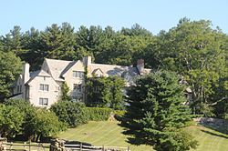
Rye House is a historic summer estate property at 122-132 Old Mount Tom Road in Litchfield, Connecticut. Developed in 1910 for a wealthy New York City widow, it is a prominent local example of Tudor Revival architecture, and a major example of the trend of country estate development in the region. The property was listed on the National Register of Historic Places in 2000.

4.0 km
The Sunny Ridge Historic District encompasses a historic former crossroads village in Washington, Connecticut. It consists of properties abutting the triangular intersection of Sunny Ridge Road, Nettletown Hollow Road, and Old Litchfield Road. This area was in the 18th and 19th centuries a stop on a north–south stagecoach and mail route. It was listed on the National Register of Historic Places in 1995.
4.5 km
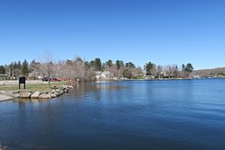
Bantam Lake is the largest natural lake in Connecticut, covering 947 acres in the towns of Morris and Litchfield. Much of the land at the northern end of the lake, including the peninsula of Marsh Point, is protected by the White Memorial Foundation and home to a wide array of bird species.
It is lined by campgrounds, camps for kids and has facilities for various water sports. The lake also has two public beaches, Morris Town Beach and Sandy Beach.
It is home to the Bantam Lake Ski Club, the oldest, continuously operating water ski club in the United States, as well as the Litchfield Hills Rowing Club which offers Summer and Fall and Masters programs.

4.5 km
Camp Columbia State Park/State Forest is a public recreation area and state forest located in the town of Morris in Litchfield County, Connecticut. The 600-acre site was once the rural campus of Columbia University's Engineering Department. The majority of the property has been designated as a state forest; the acreage designated as a state historic park includes the frontage on Bantam Lake and the site of the former university buildings. It is managed by the Connecticut Department of Energy and Environmental Protection.
4.6 km
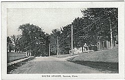
Bantam is a borough in Litchfield County, Connecticut, United States. The population was 720 at the 2020 census. It is part of the town of Litchfield.
On July 10, 1989, many of the buildings in Bantam were heavily damaged by a tornado that ripped through Litchfield and New Haven Counties. The storm also caused considerable damage to the Litchfield County town of Thomaston, and to the New Haven County towns of Waterbury, Hamden and North Haven.
It is managed by the Connecticut Department of Energy and Environmental Protection.
