
 English
 Français

Holms Water
The Holms Water is a river and a tributary of the Biggar Water, which is a tributary of the River Tweed, in the parish of Broughton, Glenholm and Kilbucho in the Scottish Borders area of Scotland, near Glenkirk, Stanhope, Peeblesshire and Hearthstane.
Nearby Places View Menu

920 m
Broughton, Glenholm and Kilbucho
Broughton, Glenholm and Kilbucho is a parish in Peeblesshire in the Scottish Borders, 11 miles south-west of Peebles, lying in the upper part of the valley of the River Tweed in the Southern Uplands. It is a union of three former parishes of bearing these names and the united parish is bound by Kirkurd on the north, Stobo on the east, Drumelzier on the south-east, Culter and Biggar, South Lanarkshire on the west and by Skirling in the north-west. For 4½ miles the eastern border of the parish follows the northward flowing Tweed. It is 9½ miles long north-to-south and 3½ miles wide. The only village is Broughton.
This parish comprehends the old parish of Broughton in the north, and Glenholm in the south-east and Kilbucho on the south-west. In accordance with the deed of annexation, all three names are retained in the name of the united parish. Biggar Water, which forms the boundary between the Broughton and the other two, flows in an easterly direction and, before joining the Tweed, is joined in turn by Kilbucho Burn, Broughton Burn and Holms Water, each of which forms valleys containing the parishes that bear their names.
The origin of the name Glenholm is obviously the valley of the Holms. Kilbucho, also spelled Kilbeuhhoe, Kilbochoe,
Kilbocho, and Kirkbucho, is probably the Gaelic prefix "Kil" meaning chapel together with the name of the Venerable Bede or St Bega or St Bees. "Brough" in Broughton may refer to "burgh" or more likely the Scots term Brough or Bruch, meaning circle, of hills.
The united parish was established by the Presbytery of Biggar in 1794 and a new church was built in 1804 at a convenient central location for the united parish. While within Kilbucho, the church is located just south of the village of Broughton and across Biggar Water. It is now a member of the linked "Parishes of Upper Tweeddale". Which is made up of the four linked Parishes of:
Broughton, Glenholm and Kilbucho
Skirling
Stobo and Drumelzier
Tweedsmuir
At the time the three old parishes were united their area and population was :
At the same time the north-west portion of Kilbucho, around Hartree and Hartree Hills, was transferred to the parish of Culter in Lanarkshire, although this portion remained in Peeblesshire. This had an area of 1712 acres. However this portion was returned to the united parish in 1891, so that Culter became a parish entirely within Lanarkshire.
For some time the three parishes continued to exist for some civil purposes. They continued as Registration Districts until 1870 and to have separate parish schools.
The civil parish of Broughton, Glenholm and Kilbucho is covered by the Upper Tweed Community Council (which also includes part of Drumelzier).
The civil parish has a population of 648 (in 2011) and its area is 19,797 acres.
1.4 km
Broughton railway station (Scotland)
Broughton railway station served the village of Broughton, Scottish Borders, Scotland from 1860 to 1950 on the Symington, Biggar and Broughton Railway and Talla Railway.
1.5 km
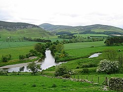
Biggar Water
Biggar Water is a river in Lanarkshire and Peeblesshire, in the Southern Uplands of Scotland.
It forms part of the River Tweed system. It rises, as Biggar Burn, in the north-east of the parish of Biggar, South Lanarkshire and flows about 6+3⁄4 miles (10.9 km) generally south-westerly toward the town of Biggar, where it becomes Biggar Water. It then flows about 5 miles (8.0 km) eastwards before its confluence with the Tweed 3⁄4 mile (1.2 km) mile north-east of Drumelzier in Peeblesshire.

1.8 km
Wrae Tower
Wrae Tower is a ruined 16th-century stone tower house, located in the upper Tweed Valley in the Scottish Borders area of Scotland, and similarly south of the village of Broughton. The ruin is at grid reference NT115332, 3 km south-west of Drumelzier. Only a fragment of the north-east corner stair tower, around 9m high and 4m across, remains standing. A single jamb represents the north-west ground floor entrance to the tower and crowning the north-east wall is rough corbelling, which supports the remains of a parapet. The tower was probably built by the Tweedies of Drumelzier, who owned the surrounding lands since 1320.