
 English
 Français

St John the Evangelist's Church, Farnworth
St John the Evangelist's Church is in Church Street, Farnworth, Greater Manchester, England. It is an active Anglican parish church in the deanery of Bolton, the archdeaconry of Bolton, and the diocese of Manchester. Its benefice is united with those of St Peter, Farnworth, Holy Trinity, Prestolee, and St Saviour, Ringley. The church is recorded in the National Heritage List for England as a designated Grade II listed building.
Nearby Places View Menu

202 m
Farnworth railway station
Farnworth railway station serves the town of Farnworth, in the Greater Manchester, England. The station underwent several name changes before the present name was adopted in 1974.
It lies on the Manchester-Preston Line 8+1⁄2 miles (13.7 km) north of Manchester Victoria, though only local services run by Northern Trains call here.
The station received a minor upgrade in 2009, with the addition of automated electronic information display systems and automated announcements audio system similar to the system at Lostock station. A more substantial rebuild, involving platform realignment, was undertaken in 2015-2016 as part of works to electrify the Manchester-Preston line. The station has a ticket office, which is staffed from 06:30 to 13:00 on weekdays only (closed Saturdays and Sundays). Outside of these times, tickets must be purchased on the train or prior to travel. Step-free access to both platforms is via ramps from the station entrance.
388 m
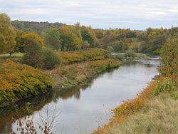
River Croal
The River Croal is a river located in Greater Manchester, England. It is a tributary of the River Irwell.
Rising at the confluence of Middle Brook and Deane Church Brook, it flows eastwards through Bolton, collecting Gilnow Brook and the larger River Tonge at Darcy Lever. Most of the river is culverted through Bolton town centre, running under Knowsley Street, Market Place and Bridge Street.
Before 1836, the River Croal formed the boundary between the townships of Great and Little Bolton.
The name of the river is derived from the Old English croh and wella, the winding stream. It was possibly originally called the Middlebrook along its entire length as early references mention the Mikelbrok, (mycel and broc), the great stream but not the Croal.
It meets the Irwell at Nob End, Kearsley after a total course of around ten miles.

615 m
Farnworth Town Hall
Farnworth Town Hall is a municipal building in Market Street, Farnworth, Greater Manchester, England. The town hall, which was the headquarters of Farnworth Borough Council, is a grade II listed building.

681 m
Moses Gate Country Park
Moses Gate Country Park, part of which is also known as Crompton Lodges, (National Grid Ref: SD 749063) is a 750 acre (300 hectare) site situated at Moses Gate in the Croal and Irwell Valleys 3 miles (4.8 km) south of Bolton town centre on the A6053 road which connects Farnworth to Little Lever. It is a Local Nature Reserve.