


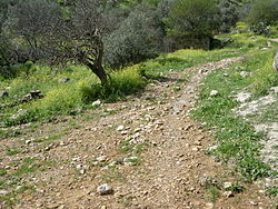
Mansurat al-Khayt (منصورة الخيط), ou al-Kheit, est un village arabe palestinien du sous-district de Safed. Comme pour des centaines d'autres villages, il a subi un nettoyage ethnique pendant la guerre israélo-arabe de 1948, dans son cas précis le 18 janvier 1948. Ses habitants s'étant réinstallés, ils sont poussés à l'exil après la fin de la guerre, en 1949, par Israél.
Location

8 m
See Mansura for other sites with similar names.
Mansurat al-Khayt was a Palestinian Arab village in the Safad Subdistrict. It was depopulated during the 1947–48 Civil War in Mandatory Palestine on January 18, 1948. It was located 11.5 km east of Safed, 1 km west of the Jordan River.
1.2 km
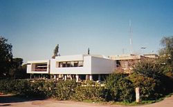
Kfar HaNassi is a kibbutz in northern Israel. Located in the Korazim Plateau, 35 km north of the Sea of Galilee, and 6 km east of Rosh Pinna, it falls under the jurisdiction of Upper Galilee Regional Council. In 2024 it had a population of 825.

2.2 km
Tuba-Zangariyye or Tuba al-Zanghariyya is a Bedouin town in the Northern District of Israel. Located in the Korazim Plateau, it achieved local council status in 1988. It was formed by the merger of two villages, Tuba and al-Zangariyye. Populated by the Bedouin tribe of El Heib, Tuba is situated near Kfar Hanassi, overlooking the Jordan River, and sits 250 meters above sea level. In 2024 it had a population of 7,173.
3.1 km
Rosh Pina Stream is a stream in the Upper Galilee that drains the eastern slopes of Mount Canaan. It originates on Mount Canaan, descends through the settlement of Rosh Pinna, and flows into the Jordan River. Along the stream, three springs emerge: Ein Gey-Onni, Ein Pina, and Ein Kadan. The upper part of the stream is a declared nature reserve covering an area of 273 dunams, designated on July 31, 2007.

3.9 km
Mishmar HaYarden was a moshava that was established in the Upper Galilee in northern Israel during the First Aliyah. It was destroyed during the 1948 Arab–Israeli war in 1948. Its Hebrew name meant Guardian of the Jordan. The village was re-established as new Mishmar HaYarden.