


Tienhoven est un village qui fait partie de la commune de Vijfheerenlanden dans la province néerlandaise de Hollande-Méridionale. Le village compte environ 730 habitants. Tienhoven a été une commune indépendante jusqu'au 1er janvier 1986. Elle a fusionné avec Hei- en Boeicop, Leerbroek, Lexmond, Meerkerk, Nieuwland et Ameide pour former la nouvelle commune de Zederik.
Portail des Pays-Bas
Location
1 explorer visited this place
871 m
Lopik is a municipality and a town in the Netherlands, in the province of Utrecht, close to the Lek river.

1.0 km
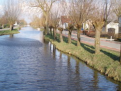
Tienhoven is a village in the Dutch province of Utrecht. It is a part of the municipality of Vijfheerenlanden, and lies about 10 km southwest of IJsselstein.
Tienhoven was a separate municipality in the province of South Holland between 1817 and 1986, when it became part of Zederik. When Zederik merged into the new municipality Vijfheerenlanden in 2019, it became a part of the province of Utrecht. The name of the town has changed to Tienhoven aan de Lek to distinguish it from Tienhoven, Stichtse Vecht, in the province of Utrecht.
The village was first mentioned in 1253 as Thienhoeuen, and means "ten parcels of land". In 2019, the name was officially changed to Tienhoven aan de Lek to distinguish from the other Tienhovens. The Protestant church dates from the 12th century, and was enlarged in the 14th and 15th century. The tower dates from the 15th century. In 1840, it was home to 238 people.

1.6 km
The KNMI-mast Cabauw is a 213-metre high guyed mast for meteorological measurements at Cabauw, the Netherlands.
In 1972 at Cabauw a 213 metres high mast was specifically built for meteorological research to establish relations between the state of the atmospheric boundary layer, land surface conditions and the general weather situation for all seasons. The Cabauw mast is located in the western part of the Netherlands in a polder 0.7 metres below average sealevel. This site was chosen, because it is rather representative for this part of the Netherlands and because only minor landscape developments were planned in this region. However, significant changes are the removal of the trees along a road east of the mast in 1975, and the building of houses in the village of Lopik east of the mast in more recent years.
The North Sea is more than 50 km away to the WNW. The nearby region is agricultural, and surface elevation changes are at most a few metres over 20 km. Within 40 km radius there are four major synoptic weather stations, among which is the regular radiosonde station at De Bilt, ensuring a permanent supporting mesoscale network. Near the mast, the terrain is open pasture for at least 400 metres in all directions, and in the WSW direction for 2 km. Farther away, the landscape is generally very open in the West sector, while the distant East sector is rather rough.
The distant North and South sectors are mixed landscapes, much pasture and some windbreaks. So the highest mast levels have in all directions a long fetch of landscape roughness which is usefully similar to the roughness observed in the lower surface layer. On the mast itself no undisturbed measurements can be made below 20 metres. Therefore, auxiliary 20 metres masts are installed to the SE and the NW at sufficient distance from the mast foot building. South of the mast is a well-kept observation field for micrometeorological observations, including soil heat flux, soil temperatures and various radiation measurements; north of the mast is a spare observation field. The soil consists of 0.6 metres of river-clay, overlying a thick layer of peat. The water table is about 1 metre below the surface, but can be higher during wet periods.
The mast is a closed cylinder of 2 metres diameter, with an elevator inside. It is guyed at four levels, and carries booms at 20 metres intervals in three directions. The 9.4 metres booms can be swung up hydraulically, so that instruments at their ends can be handled from an upper balcony; this swivelling mounting allows much longer booms than the customary sideways-sliding construction. Permanent signal cables in the boom tubes run through the hollow swivel axis, so during boom motion they are only torsion-deformed, a more endurable load than bending. Built around the mast foot is a 200 m2 streamlined building for registration and maintenance purposes.
On top of the mast, a compact weather radar was installed in 2007, measuring precipitation up to a radius of 60 km around the mast.

1.9 km
Ameide is a city in the Dutch province of Utrecht. It is a part of the municipality of Vijfheerenlanden, and lies about 9 km southwest of IJsselstein.
Ameide received city rights in the 14th century.
Ameide was a separate municipality in the province of South Holland until 1986, when it became part of Zederik. When Zederik merged into the new municipality Vijfheerenlanden in 2019, it became a part of the province of Utrecht.
In 2001, the village of Ameide had 3087 inhabitants. The built-up area of the village was 0.58 km², and contained 1083 residences.
The statistical area "Ameide", which also can include the surrounding countryside, has a population of around 3040.
2.8 km
Jaarsveld is a village in the Dutch province of Utrecht. It is a part of the municipality of Lopik, and lies about 7 km southwest of IJsselstein.
Jaarsveld used to be a separate municipality, covering a large part of the current municipality of Lopik south of the Lopiker Wetering and Enge IJssel rivers. It merged with the municipality of Lopik in 1943. A large part of the town of Lopik is actually built in the former municipality of Jaarsveld.
