
 English
 Français
Roe Beck
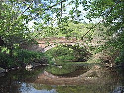
Roe Beck also known as the River Roe in its lower reaches, is a beck that flows through Cumbria, England. It is a lower tributary of the River Caldew which it joins near Gaitsgill south of Dalston. The total length of the beck including Peel Gill is 20.8 kilometres (12.9 mi) and it has a catchment of 69 square kilometres (27 sq mi), which includes the area of its major tributary the River Ive.
Nearby Places View Menu

1.7 km
Unthank, Dalston
Unthank is a village near Dalston in Cumbria, England. It is first mentioned in writing in 1332.

1.7 km
Rose Castle
Rose Castle is a fortified house in the parish of Dalston, Cumbria, England. It was the residence of the bishops of Carlisle from 1230 to 2009, and has been a peace and reconciliation centre since it was sold by the Church Commissioners to the Rose Castle Foundation in 2016. The castle is a grade I listed building.
The medieval castle consisted of four irregular ranges around a courtyard, but it has been altered several times. Significant changes took place in approximately 1665, when bishop Edward Rainbowe had the east and south ranges demolished and remodelled the remaining structure, including the chapel of 1487–49. Further large changes took place between 1828 and 1831 under bishop Hugh Percy, who commissioned Thomas Rickman to remodel the entrance chapel, and west wing. Rickman also altered the Strickland Tower, a pele tower which has been dated to both c. 1300 and c. 1400 and which is attached to the rest of the castle by a short stretch of curtain wall.

1.9 km
Raughton Head
Raughton Head is a hamlet in Cumbria, England, located 8 miles (13 km) south of Carlisle.

2.5 km
Stockdalewath
Stockdalewath is a small village in the ceremonial county of Cumbria, but in the historic county of Cumberland, approximately 7.5 miles south of Carlisle in the extreme northwest of England. It is located on the River Roe, and is in the civil parish of Dalston.
As of the 2011 census, the population is estimated to be 74.
Archaeological evidence, mostly based on aerial surveys of crop marks, suggests that Stockdalewath was a rural settlement in Roman Cumbria. Within a half mile of the village are three camps thought to be Roman, with the names Castlesteads, Stoneraise, and Whitestones. They are equal distance from each other and form a triangle.