


Roundhill is a Roanoke, Virginia neighborhood located in northwest Roanoke. It borders the neighborhoods of Airport on the north, Williamson Road on the south, Preston Park on the east, and Fairland, Melrose-Rugby and Washington Park on the west opposite Interstate 581.
Location

1.1 km
Valley View Mall is an 800,000-square-foot regional shopping mall located in the Roundhill neighborhood of Roanoke, Virginia. It is located near the interchange of I-581/US 220 with Hershberger Road in the northwest section of the city.
Most outparcel locations around Valley View Mall have been developed into restaurants, retail stores, offices, and hotels. Major surrounding stores include Ashley Furniture, Dick's Sporting Goods, Best Buy, Grand Home Furnishings, Walmart, and Target. Regal Cinemas has a 16 screen movie theater with stadium seating at an outparcel location, which replaced a smaller six screen cinema inside the mall.
1.3 km
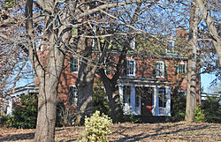
Huntingdon is a historic plantation house located at Roanoke, Virginia. It was built about 1819, and is a 2+1⁄2-story, five-bay, Federal style brick dwelling. It has a central-passage-plan and an integral two-story rear ell. The front and side elevations feature mid-19th century Greek Revival style porches. The house was restored and improved in 1988–1989. Also on the property is a contributing family cemetery and an outbuilding believed to have been a slave house.
It was listed on the National Register of Historic Places in 1991.
1.4 km
Washington Park is a neighborhood located in central Roanoke, Virginia, that initially developed in the 1920s as an early Roanoke suburb. It borders the neighborhoods of Roundhill on the north and Williamson Road on the north and east, Gainsboro and Harrison on the south, and Melrose-Rugby on the west. Its northern and eastern boundary is concurrent with Interstate 581, and its southern boundary is concurrent with U.S. Route 460. As of the 2000 census, Harrison had a population of 1,254 residents, with 531 households.
1.6 km
Preston Park is a neighborhood located in northeast Roanoke, Virginia. It borders the neighborhoods of Williamson Road on the south, Monterey and Hollins on the east, and Roundhill and the Airport on the west. The northern border is shared with Roanoke County. The name of the neighborhood reflects the fact that the large park of the same name is located within the neighborhood.
1.8 km
Fairland is a Roanoke, Virginia neighborhood located in north, central Roanoke across Interstate 581, opposite Valley View Mall. It borders the neighborhoods of Miller Court/Arrowood and Villa Heights on the west and Roundhill and Melrose-Rugby on the east. As of the 2000 U.S. Census, Fairland has a population of 1,492 residents.