
 English
 Français
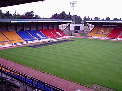
McDiarmid Park
Le McDiarmid Park est un stade de football situé à Perth. Ce stade de football d'une capacité de 10 696 places toutes assises accueille, depuis sa construction en 1989, les matches à domicile de Saint Johnstone, club évoluant en Scottish Premiership. De 1995 à 1998, le stade est aussi utilisé pour les matchs à domicile du club de rugby à XV, les Caledonia Reds, aujourd'hui disparu.
Nearby Places View Menu
4 m
McDiarmid Park
McDiarmid Park is a stadium in Perth, Scotland, used mainly for association football. It has been the home ground of St Johnstone since its opening in 1989. The stadium has an all-seated capacity of 10,696.
As well as St Johnstone matches, McDiarmid Park has been chosen to host the final of the Scottish Challenge Cup on nine occasions. It has also been used for rugby union, including a full international between Scotland and Japan in 2004, several Scotland A fixtures, and some home matches of the former Caledonia Reds team.
615 m
Letham F.C.
Letham Football Club are a Scottish football club from the Letham area in the northwest of Perth. They are members of the East Region of the Scottish Junior Football Association and currently play in the Midlands Football League.

688 m
Tulloch, Perth and Kinross
Tulloch, formerly known as Bleachfield, is a residential area of Perth, Scotland, approximately 1.5 miles (2.4 km) north-west of the city centre. Tulloch is the western part of the area that borders Hillyland.
The main access road to Tulloch, from the east or west, is Tulloch Road, reached via the Crieff Road (A85), which bounds it to the south. It is also accessible, albeit less directly, from the Dunkeld Road (A912), which bounds it to the north-east, via a modern housing development. It is bounded to the north-west by the A9.
Tulloch has a small shopping precinct, Tulloch Square, located just off Tulloch Terrace. Tulloch Primary School, founded in 1969, is located on Gillespie Place. It can accommodate 400 pupils.
Primrose Crescent, a main thoroughfare which, upon merging from Tulloch Road and Hillyland, circumnavigates Tulloch's oldest residential area before joining up with Tulloch Road again just before its western junction with Crieff Road.
The skyline is dominated by several high-rise flats.
In addition to the new housing development in the north-east of Tulloch/Hillyland, homes have also been built to the north and west. These are in addition to the first development (Sandeman Court) that went up in the 1980s in the valley behind the primary school, near the railway siding at the bottom of the hill. Between the housing and the railway siding is Perth Lade, which is sourced from Low's Work, a weir on the River Almond south of Almondbank, and empties 4.5 miles (7.2 km) away into the River Tay, near Smeaton's Bridge, via the city. A walking path runs parallel to the lade. Ladeside Court, a cul-de-sac off Fairfield Avenue, takes its name from the body of water.
J. Pullar and Sons Ltd.'s Tulloch Works, a dry cleaning plant, once stood on the site of the present-day Bracken Brae. At the turn of the 20th century, architectural firm comprising John Honeyman, John Keppie and Charles Rennie Mackintosh designed a row of buildings for workers at the dyeworks. They were single-storey, semi-detached roughcast cottages. There were also two two-storey blocks containing a total of ten flats. The eight cottages remain, today's 61–75 Tulloch Terrace; the two flats have been demolished. Pullars also built Tulloch School, for their workers' children, in 1895. The school closed in 1911, and the building was later used by the Tulloch Institute.
From certain parts of Tulloch, views are afforded of the hills beyond Scone to the east, including an obelisk on the 279-foot (85 m) summit of a hill near Muirend. To the north, the Grampian Mountains can be seen.

700 m
Huntingtower Castle
Huntingtower Castle, once known as Ruthven Castle or the Place of Ruthven, is located near the village of Huntingtower beside the A85 and near the A9, about 5 km NW of the centre of Perth, Perth and Kinross, in central Scotland, on the main road to Crieff. This castle is the subject for several local ghostlore stories.

741 m
Hillyland
Hillyland is a suburban area of Perth, Scotland, approximately 2.0 miles (3.2 km) west-northwest of the centre of Perth. It borders Tulloch, which is located to the north and northeast. Newhouse Road separates Hillyland from Letham to the east.
Hillyland lies immediately to the east of the A9 and south of the A85 (Crieff Road). As its name suggests, the area is centred on a hill, which is 55.8 metres (183 ft) at its highest point.
In 1909, city reports described a "special drainage district" called Tulloch and Hillyland.