


Trung An is a ward in Đồng Tháp province, Vietnam. It is one of 102 communes and wards in the province following the 2025 reorganization.
Book your tour near
Trung An
Book Now
4.1
in partnership with
GetYourGuide.com
Location
1 explorer visited this place
2.6 km
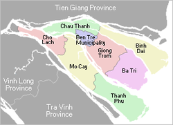
Châu Thành is a rural district of Bến Tre province in the Mekong Delta of Vietnam. As of 2019 the district had a population of 175,893. The district covers an area of 229 km2. The district capital lies at Châu Thành.
The district lies to the north of Bến Tre Province, the Tiên River, the towns of Bến Tre and Mỹ Tho and the districts of Châu Thành and Cai Lậy in Tiền Giang province. To the south is the Hàm Luông River and the Chợ Lách and Mỏ Cày districts.

3.3 km
The Battle of Rạch Gầm-Xoài Mút was fought between the Vietnamese Tây Sơn forces and an army of Siam in present-day Đồng Tháp province of Vietnam on January 20, 1785. It is considered one of the greatest victories in Vietnamese history.

3.3 km
Mỹ Tho is a former city in the Tiền Giang province in the Mekong Delta region of Southern Vietnam. It has a population of approximately 169,000 in 2006 and 220,000 in 2012. It is the regional center of economics, education and technology. The majority ethnic group is the Kinh; minority groups include the Hoa, the Cham and the Khmer people. Boat rides on the Mỹ Tho River are popular with tourists, and the city is known for hủ tiếu Mỹ Tho, a type of rice noodles soup.
Mỹ Tho ceased to exist as a municipal city on 1 July 2025, following the elimination of district level units in Vietnam.

4.0 km
Rạch Miễu Bridge is a cable-stayed bridge in the Mekong Delta, Vietnam. The bridge connects Đồng Tháp Province with Vĩnh Long Province, over the Tiền River . Construction began on 30 April 2002 and was completed on 19 January 2009, when the bridge was inaugurated. With a total length is 8,331 metres, including approach ramps, the main bridge is 2,868 metres long.
Under the original schedule, the bridge would have been completed and opened for traffic in late 2007.
Length: 8331 m including approach ramps. The main bridge consists of two separate parts No. 1 and No. 2 for a total length of 2868 m, which is a cable-stayed structure layout 117 m-270 m-117 m pace, not static navigational clearance height 37.5 m. In the middle of the bridge is island Thoi Son. The 990-metre-long bridge consists of two spans up to 90 m in length to inform the way the boat is 7-metre-high reinforced concrete beams pre-stressed construction the balanced cantilever method. The span girder bridge that leads pre-stressed concrete reinforced each span 40 metres in length. The ramp has a total length of two 5463 m and two main bridges with total length of 2868 m crosses the tributaries of Tien Giang and Thoi Son.
At 7:30 am on 20 August, the Ministry of Transport and the provinces of Ben Tre and Tien Giang held a connection with two cable-stayed span of the bridge to connect the provinces.
The length of the main span is 270 m, and the clearance is 37.5 m to allow ships of 10,000 tons go through.
Bridge width: 12–15 m with two lanes of traffic
General construction contractors: joint venture CIENCO1 - CIENCO5 - CIENCO6
Bridge load: 30 tons
Total investment: VND 1,400 billion

4.1 km
Thới Sơn Island is a river island on the Mỹ Tho River, Thới Sơn Ward, Đồng Tháp Province, Vietnam. Before the 2025 administrative merger, it belonged to Tiền Giang Province. The islet is a popular tourist destination.