


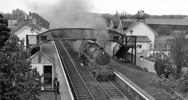
Braidwood railway station served the village of Braidwood, South Lanarkshire, Scotland from 1848 to 1962 on the Caledonian main line.
Book your tour near
Braidwood railway station
Book Now
4.1
in partnership with
GetYourGuide.com
Location
1 explorer visited this place
910 m
Braidwood is a small village near Carluke, in South Lanarkshire, Scotland. The medieval barony of Braidwood included the Tower of Hallbar.
Braidwood House, former seat of Lord Clydesmuir, is one of the major local landmarks. Over the years it has been a home for sufferers of cerebral palsy run by Capability Scotland and is now home to the South of Scotland offices of the Forestry Commission. Braidwood House was also briefly home to the Airborne Initiative, formerly of Glengonnar outside Abington, who specialised in outward-bound style training for young offenders. However the programme's funding was subsequently withdrawn by the Scottish Executive in 2004, after the airing of a controversial BBC Scotland documentary Chancers. The building has now fallen into disrepair, but there is still a small animal cemetery in the overgrown house grounds.
Many houses have been built in Braidwood in the past couple of years, primarily on the former sites of the vehicle dismantlers of Alan Gray at Nellfield. New houses have also been constructed opposite the pond beside the Beanshields road by Modern Homes. Another new housing estate is being built by Allanwater at the site of the former Scott's garden centre; with houses expected to be released in autumn 2025.
The "Nellfield Garage" petrol station is still functioning along with a shop. The village's sole pub "The Station Inn" reopened in early April 2025 after an £155,000 refurbishment by Heineken-owned Star Pubs.

1.1 km
The A73 is a former trunk route in Scotland, that connects the M74 at Abington, Jct. 13 to the M80 motorway at Cumbernauld. Running for approximately 37 miles, it passes through the towns of Lanark, Carluke, Newmains, Chapelhall and Airdrie. Formerly a main route connecting the north of Scotland to England it has less importance these days, and is now merely a local feeder to the two motorways with which it connects.
The sections between Abington & Carluke and Cumbernauld & Newhouse were the first sections to be downgraded from a trunk route to a secondary route, following the construction of the shorter M73 further west, which connected the M74 at Jct. 4. This motorway removed the need for vehicles from the north to use the A73 to reach England.
Following this downgrading, the remaining section of A73 between Carluke and Newhouse remained a trunk route for vehicles travelling between Glasgow and Peebles. For this reason, two new sections of dual carriageway were built between Bellside & Newmains and Bogside & Law, as well as a new bypass for the town centre of Carluke, where the trunk route continues as the A721.
Eventually though, the M74 was completed and it became easier for vehicles travelling from Peebles to Glasgow, to use the A702 trunk route instead, which also joins the M74 at Abington.
For this reason, the entire length of the A73 was downgraded to a secondary route, although it is still heavily trafficked, especially between Lanark and the M8 at Newhouse.

1.6 km
The Tower of Hallbar, also known as Hallbar Tower and Braidwood Castle, is a 16th-century tower house, located to the west of the River Clyde in South Lanarkshire, Scotland. The tower is situated above the Braidwood Burn, 3.5 km south-west of Carluke, and 1.5 km east of Crossford. It has been restored and is let out as holiday accommodation.

1.7 km
Clydesdale was a local government district in the Strathclyde region of Scotland from 1975 to 1996. The district was called Lanark when created in 1975, but changed its name to Clydesdale in 1980. Clydesdale was an old name for the county of Lanarkshire, one of the historic counties of Scotland. Both the names Clydesdale and Strathclyde refer to the area's position in the valley of the River Clyde.

2.0 km
Lee Castle, also known as The Lee, is a castellated mansion in Auchenglen, a branch of the Clyde Valley in South Lanarkshire, Scotland. It is located 1.5 kilometres south of Braidwood, and 4 kilometres north-west of Lanark. Lee was the seat of the Lockharts of Lee from its establishment in the 13th century until 1919, though the present house is the result of rebuilding in the 19th century.
The house is protected as a category B listed building, and the grounds are included in the Inventory of Gardens and Designed Landscapes in Scotland, the national listing of significant gardens.
History
The station opened in August 1848 by the Caledonian Railway. To the west was the goods yard with sidings that served Nellfield Saw Mills. To the east was the signal box and more sidings, one to the north serving Meadow Brick Works. The station closed to passengers on 2 July 1962 and closed to goods traffic on 6 July 1964.
Book your tour near
Braidwood railway station
Book Now
4.1
in partnership with
GetYourGuide.com
