
 English
 Français
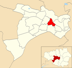
Claremont (ward)
Claremont (ward) is an electoral ward of Salford, England. It is represented in Westminster by Rebecca Long-Bailey MP for Salford and Eccles. A profile of the ward conducted by Salford City Council in 2014 recorded a population of 10,166.
Nearby Places View Menu
349 m
Irlams o' th' Height
Irlams o' th' Height is a suburb of Salford, Greater Manchester, England, on top of the Irwell Valley, on higher ground than Pendleton, hence the name.
The first part of the name derives from the Irlam family that ran the Pack Horse Inn in the 17th and 18th centuries.
It was first recorded in the parish of Eccles in 1180. The village became prosperous in the 19th century due to the Industrial Revolution and became a well-established community of handloom weavers.
Some parts of the area are now designated as a conservation area, centring on Queen Street, King Street and Claremont Road, as these retain the early street pattern. Thirty buildings are recognised as being of archaeological or historic interest in the Greater Manchester Sites and Monuments Register. The conservation area was designated in 1991 and is 1.02 hectares (2.52 acres) in size.

465 m
Greater Manchester
Greater Manchester is a metropolitan and ceremonial county in North West England. It borders Lancashire to the north, West Yorkshire and Derbyshire to the east, Cheshire to the south, and Merseyside to the west. Its largest settlement is the city of Manchester.
The county has an area of 1,276 km2 (493 sq mi) and is highly urbanised, with an estimated population of 3,009,664 in 2024. Manchester is located in the centre of the county, with the city of Salford immediately adjacent to the west. Other large settlements include Rochdale in the north-east, Stockport in the south-east, Sale in the south-west, Wigan in the far north-west, and Bolton in the north-west. The majority of the county's settlements are part of the Greater Manchester Built-up Area, which extends into Cheshire and Merseyside and is the second most populous urban area in the United Kingdom. For local government purposes the county comprises ten metropolitan boroughs: Manchester, Salford, Bolton, Bury, Oldham, Rochdale, Stockport, Tameside, Trafford and Wigan. The borough councils collaborate through the Greater Manchester Combined Authority. Greater Manchester was created on 1 April 1974 from parts of north-east Cheshire, south-east Lancashire, and a small part of the West Riding of Yorkshire.
The centre and south-west of Greater Manchester are lowlands, similar to the West Lancashire Coastal Plain to the north-west and the Cheshire Plain to the south-west. The north and east are part of the Pennines: the West Pennine Moors in the northwest, the South Pennines in the northeast and the Peak District in the east. Most of the county's rivers rise in the Pennines and are tributaries of the Mersey and Irwell, the latter of which is itself a tributary of the Mersey. The county is connected to the Mersey Estuary by the Manchester Ship Canal, which for its entire length within Greater Manchester consists of canalised sections of the Mersey and Irwell.
What is now Greater Manchester was largely rural until the Industrial Revolution, when the region underwent rapid industrialisation. The area's towns and cities became major centres for the manufacture of cotton textiles, aided by the exploitation of the Lancashire coalfield. The region was also an engineering and scientific centre, leading to achievements such as the first inter-city railway. Following deindustrialisation in the mid-20th century the county has emerged as a major centre for the service sector, media and digital industries. It is also recognised for its contributions to guitar and dance music, and for its football teams.

831 m
Pendlebury Children's Hospital
Pendlebury Children's Hospital was a children's hospital in Pendlebury, Salford, England. It was managed by the Central Manchester University Hospitals NHS Foundation Trust.

890 m
Pendlebury
Pendlebury is a town in the City of Salford, Greater Manchester, England. The population at the 2011 Census was 13,069. It lies 4 miles (6 km) north-west of Manchester, 3 miles (5 km) north-west of Salford and 6 miles (10 km) south-east of Bolton.
Historically in Lancashire, Pendlebury, together with the neighbouring settlements of Swinton and Clifton, formed the municipal borough of Swinton and Pendlebury. Pendlebury saw extensive coal extraction from several collieries until the closure of Agecroft Colliery in the 1990s.