


La chapelle Saint-Gilles est un édifice religieux catholique situé à Mianoye (commune d’Assesse), en province de Namur (Belgique). Ancienne chapelle castrale construite en 1731, la chapelle est classée au patrimoine immobilier de la Wallonie (1949).
Book your tour near
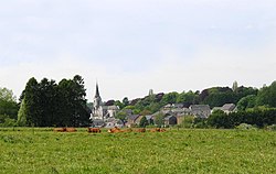
Chapelle Saint-Gilles de Mianoye
Book Now
4.4
in partnership with
GetYourGuide.com
Gallery


Sponsored
Location
1 explorer visited this place
2.5 km
Assesse is a municipality of Wallonia located in the province of Namur, Belgium.
On 1 January 2006, Assesse had a total population of 6,252. The total area is 78.16 km2 which gives a population density of 80 inhabitants per km2.
The municipality consists of the following districts: Assesse, Courrière, Crupet, Florée, Maillen, Sart-Bernard, and Sorinne-la-Longue.
The village of Crupet is noted for its grotto dedicated to Saint Anthony of Padua, the Crupet Castle, a moated medieval donjon, and its windmills.

4.4 km
Crupet is a village of Wallonia and a district of the municipality of Assesse, located in the province of Namur, Belgium.
Until 1977, it was itself a municipality. The postal code of Crupet is 5332.
It is a member of the organisation Les Plus Beaux Villages de Wallonie.
The centre of the village is dominated by the Grotto of St Anthony of Padua. The grotto was designed by the local curate Gerard and inaugurated on 12 July 1903. It features 22 religious-themed statues. Many of them depict scenes from the life of St Anthony of Padua. The Castle of Crupet, a medieval farm-chateau is situated below the village centre, and a little to the north, next to the river.

4.4 km
Crupet Castle or Carondelet Castle, is a medieval moated donjon or fortified farmhouse in the village of Crupet, Wallonia, since 1977 part of the municipality of Assesse, province of Namur, Belgium. It was built in the 11th or 12th century, and the lords of the castle later became vassals of Liège.
The castle was owned by the Crupet family until 1510, followed by the Carondelet family. The name and crest of the family is present in various places in the castle. In 1667, the castle was passed to the Mérode family where it remained until the French Revolution.
In 1925, the castle was restored by the architect Blomme and was owned by the Limbosch family until 2008.

4.6 km
Courrière is a village of Wallonia and a district of the municipality of Assesse, located in the province of Namur, Belgium.
Until 1977, it was an independent municipality.
Courrière is located at the junction of two major roads, the A4/E411 and the N4, and consists of the compact central village, Petit-Courrière, and a large hamlet, Trieu d'Avillon, which are separated from each other by the roads.
Courrière has been an independent parish from the 18th century. At the centre of the village stands the parish church of Saint Quentin, of Romanesque origin, and next to it a fortified farmhouse, or ferme-château, the so-called Château de Courrière, the present structure of which dates from the 17th century.

5.1 km
The Condroz is a natural region in Wallonia, the French-speaking part of Belgium, located between the Ardennes and the Meuse. Its unofficial capital is Ciney. The region preserves the name of the Condrusi, a Germanic tribe which inhabited the area during and before the Roman era.
Compared to other parts of Belgium, the Condroz is a sparsely populated, agricultural area. It consists of low hills of an average altitude of about 200 to 300 meters. It is mainly situated in the provinces of Liège and Namur and also in smaller parts of the Belgian provinces of Hainaut and Luxembourg. It is bordered in the north by the Meuse river, in the east by the Ardennes, in the south by the Famenne region.
Historically, the Condroz did not stretch west of the Meuse, but today there is a western section, south of Namur and the Sambre river stretching to the Thiérache and southern Hainaut.